Social Media


Popular features
Photo

Filters

Stock vector images of Графічні межі
Discover royalty-free, professionally-designed vector art of Графічні межі for personal and commercial use.
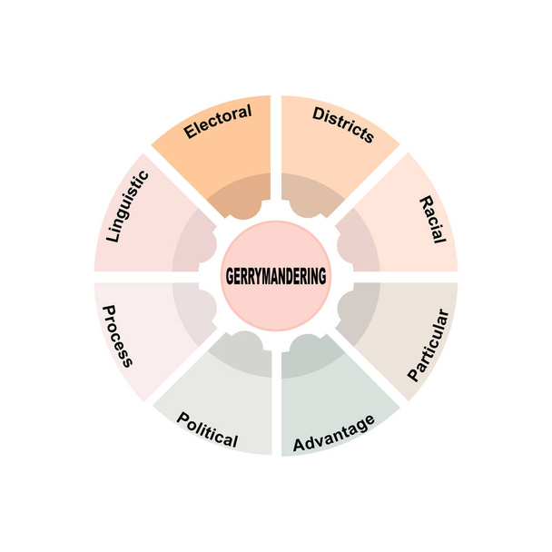
Diagram concept with Gerrymandering text and keywords. EPS 10 isolated on white background
Politics and parties related, square line color vector icon set for applications and website development. The icon set is pixelperfect with 64x64 grid. Crafted with precision and eye for quality.

Vector abstract map of Estonia with violet striped texture and striped dark background

3d vector neon isometric Italy map in turquoise colors on a dark blue background. Stylized map icon of Italy. Infographic element
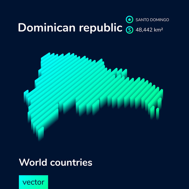
Vector digital neon isometric striped contour Dominican republic map with information about country. Geographical poster, banner of Dominican republic
Politics and parties related, square line vector icon set for applications and website development. The icon set is pixelperfect with 64x64 grid. Crafted with precision and eye for quality.

Vector abstract map of Belorus with violet striped texture and striped dark background
Personal boundaries icon. Two people face to face. Vector illustration
Cubes flat color icons with quadrant frames on white background

Administrative Map of the Greater London with Ceremonial Counties, the London Boroughs, and the Wards of the City of London as of 2022 - United Kingdom, England - Vector Map

3d vector isometric neon Moldova map in turquoise colors on a dark blue background. Stylized map icon of Moldova. Infographic element

Africa map black, vector eps 10 isolated, silhouette black and dotted

Vector abstract map of Kazakhstan with violet striped texture and striped dark background. New capital of Kazakhstan - Nur-Sultan
Quadrilateral icon in neon style. geometric figure element for mobile concept and web apps. thin line icon for website design and development, app development on black background

Geopolitical Vector Map of the Autonomous Community of Catalonia (Cataluna/Catalunya/Catalonha) with Provinces (Provincias), Judicial Areas (Partidos Judiciales), Comarques (Comarcas) and Municipalities (Municipios) as of 2022 - Spain

Singapore outline map. Map black outline Republic of Singapore

Vector illustration of administrative division map of Germany. Vector map.

Circuit board on green background
Turkish Lira financial graph flat color icons with quadrant frames on white background

Switzerland vector map colored by cantons with districts boundaries

Iran map in gray on a white background

Black and white maps of the city of Sao Paulo, Brazil

Administrative vector map of the Arnsberg region in German language, North Rhine-Westphalia, Germany

Africa map black, vector eps 10 isolated, silhouette for design

Greater Rio de Janeiro dark silhouette map isolated on white background, Brazil

3D Vermont (USA) Blueprint Grunge outline map with shadow

Andorra official flag, european country, vector illustration

Vanuatu on the globe. Earth centered at the location of the Republic of Vanuatu. Map of Vanuatu. Includes layer with capital cities.

Greece (Hellas) on the globe. Earth centered at the location of the Hellenic Republic. Map of Greece. Includes layer with capital cities.
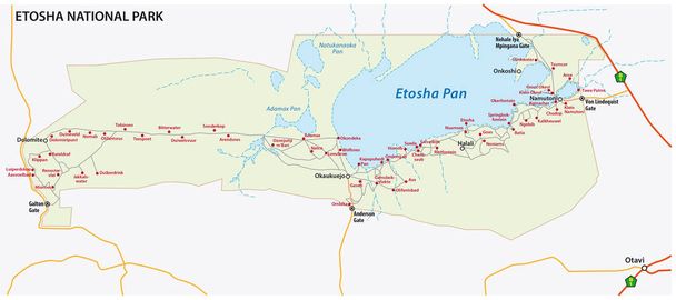
Etosha national park vector map, Namibia

Philippines on the globe. Earth centered at the location of the Republic of the Philippines. Map of Philippines. Includes layer with capital cities.

Somalia on the globe. Earth centered at the location of the Federal Republic of Somalia. Map of Somalia. Includes layer with capital cities.

Netherlands on the globe. Earth centered at the location of The Kingdom of the Netherlands. Map of the Netherlands. Includes layer with capital cities.

France on the globe. Earth centered at the location of the French Republic. Map of France. Includes layer with capital cities.
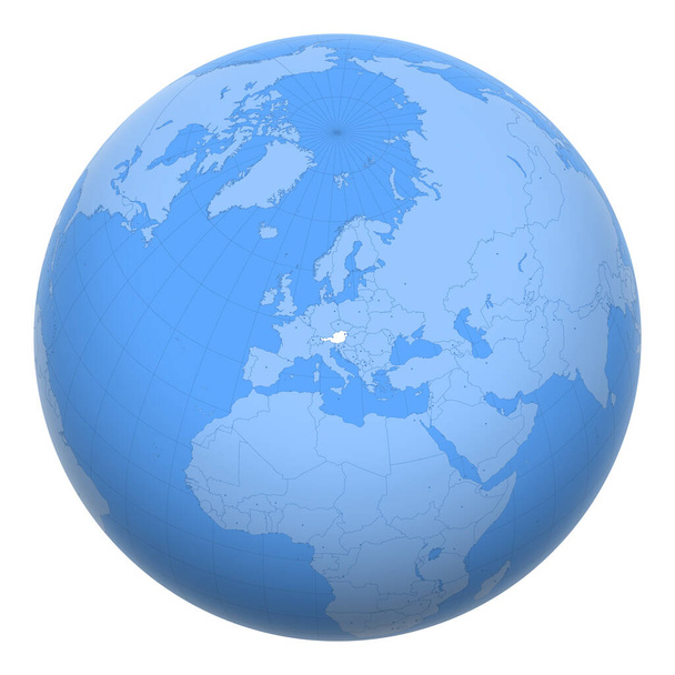
Austria on the globe. Earth centered at the location of the Republic of Austria. Map of Austria. Includes layer with capital cities.
Laptop with incognito symbol flat color icons with quadrant frames on white background

Thailand (Siam) on the globe. Earth centered at the location of the Kingdom of Thailand. Map of Thailand. Includes layer with capital cities.

Marshall Islands on the globe. Earth centered at the location of the Republic of the Marshall Islands. Map of Marshall Islands. Includes layer with capital cities.

Bangladesh on the globe. Earth centered at the location of the People's Republic of Bangladesh. Map of Bangladesh. Includes layer with capital cities.

Uganda on the globe. Earth centered at the location of the Republic of Uganda. Map of Uganda. Includes layer with capital cities.

Panama on the globe. Earth centered at the location of the Republic of Panama. Map of Panama. Includes layer with capital cities.

Ireland on the globe. Earth centered at the location of the Republic of Ireland. Map of Ireland. Includes layer with capital cities.

Djibouti on the globe. Earth centered at the location of the Republic of Djibouti. Map of Djibouti. Includes layer with capital cities.

Ecuador on the globe. Earth centered at the location of the Republic of Ecuador. Map of Ecuador. Includes layer with capital cities.

El Salvador on the globe. Earth centered at the location of the Republic of El Salvador. Map of El Salvador. Includes layer with capital cities.

Finland on the globe. Earth centered at the location of the Republic of Finland. Map of Finland. Includes layer with capital cities.
Multiple canvases flat color icons with quadrant frames on white background

Tokyo prefecture administrative and political vector map with flag

Singapore on the globe. Earth centered at the location of the Republic of Singapore. Map of Singapore. Includes layer with capital cities.

San Marino on the globe. Earth centered at the location of the Republic of San Marino. Map of San Marino. Includes layer with capital cities.

North Korea (DPRK or DPR Korea) on the globe. Earth centered at the location of the Democratic People's Republic of Korea. Map of North Korea. Includes layer with capital cities.

Malta on the globe. Earth centered at the location of the Republic of Malta. Map of Malta. Includes layer with capital cities.

Nauru on the globe. Earth centered at the location of the Republic of Nauru. Map of Nauru. Includes layer with capital cities.

Palestine on the globe. Earth centered at the location of the State of Palestine. Map of Palestine. Includes layer with capital cities.

India on the globe. Earth centered at the location of the Republic of India. Map of India. Includes layer with capital cities.

Pakistan on the globe. Earth centered at the location of the Islamic Republic of Pakistan. Map of Pakistan. Includes layer with capital cities.
Place image flat color icons with quadrant frames on white background

Malaysia on the globe. Earth centered at the location of Malaysia. Map of Malaysia. Includes layer with capital cities.

Mali on the globe. Earth centered at the location of the Republic of Mali. Map of Mali. Includes layer with capital cities.

Micronesia (FSM) on the globe. Earth centered at the location of The Federated States of Micronesia. Map of Micronesia. Includes layer with capital cities.
Photo library flat color icons with quadrant frames on white background

Algeria on the globe. Earth centered at the location of the People's Democratic Republic of Algeria. Map of Algeria. Includes layer with capital cities.

South Africa on the globe. Earth centered at the location of the Republic of South Africa (RSA). Map of South Africa. Includes layer with capital cities.

Administrative map of the Campanian capital Naples with flag, Italy

Mauritius on the globe. Earth centered at the location of the Republic of Mauritius. Map of Mauritius. Includes layer with capital cities.

Administrative and political map of the metropolitan city of Genoa in the region of Liguria Italy

Japan on the globe. Earth centered at the location of Japan. Map of Japan. Includes layer with capital cities.

Invading teenager privacy 2D vector isolated illustration
Maldives on the globe. Earth centered at the location of the Republic of Maldives. Map of Maldives. Includes layer with capital cities.

Administrative vector map of the Dusseldorf region in German language, North Rhine-Westphalia, Germany.jpg

The Gambia on the globe. Earth centered at the location of the Republic of The Gambia. Map of The Gambia. Includes layer with capital cities.

Switzerland vector map colored by cantons with districts boundaries

Vector map of the three Wadden Sea National Parks in german language, Germany
Indian Rupee financial report flat color icons with quadrant frames on white background

Political and location map of Belgium. Versatile file, every piece is selectable and editable in layers panel. Turn on and off visibility of every province in one click. Vector, eps 10.

Vector Map of the Geopolitical Subdivisions of the French Department of Gironde Including Arrondissements, Cantons and Municipalities as of 2022 - Nouvelle Aquitaine - France

Geopolitical Vector Map of the Province of Las Palmas (Canary Islands) with Jurisdictions (Partidos Judiciales), Islands (Islas) and Municipalities (Municipios) as of 2022 - Spain

Mozambique map vector illustration, scribble sketch Republic of Mozambique

Cologne city, silhouette map isolated on white background, Germany

Somerset County (New Jersey) outline map set

Colusa County (California) outline map set

Tripp County (South Dakota) outline map set

Ouachita County (Arkansas) outline map set

Polk County (Florida) outline map set

Aransas County (Texas) outline map set

Eastland County (Texas) outline map set

Hand Drawn Doodle Map Of Finland. Vector Illustration

Hand Drawn Doodle Map Of Hungary. Vector Illustration

Missouri state outline map set

Brand communication guidelines metaphors. Corporate identity concept

Tianjin city administrative map isolated on gray background, China

Philadelphia city administrative map isolated on gray background

Glasgow city administrative map isolated on white background
Avoid stressful situation color icon. Learn how to say no.Defending personal boundaries. Eliminate stressors numbers. Mental health concept. Isolated vector illustration

Vector isolated illustration of Mozambique map with neon effect.

Geopolitical Vector Map of the Autonomous Community of Castile and Leon (Castilla y Leon) with Provinces (Provincias), Judicial Areas (Partidos Judiciales), UBOST and Municipalities (Municipios) as of 2022 - Spain

Geopolitical Vector Map of the Province of Zamora (Castile and Leon) with Jurisdictions (Partidos Judiciales), UBOST and Municipalities (Municipios) as of 2022 - Spain

Geopolitical Vector Map of the Province of Almeria (Andalusia) with Jurisdictions (Partidos Judiciales), Comarques (Comarcas) and Municipalities (Municipios) as of 2022 - Spain

Administrative Map of the Alentejo Region with Intermunicipal Communities (Comunidades Intermunicipais), Districts (Distritos) and Civil Parishes (Freguesias) as of 2022 - Portugal - Vector Map

Administrative Map of the Province of Castellon (Valencian Community) with Jurisdictions (Partidos Judiciales), Comarques (Comarcas) and Municipalities (Municipios) as of 2022 - Spain - Vector Map